 istanbul golden horn
Istanbul Gouden Hoorn
GOLDEN HORN History
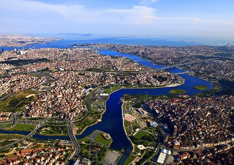
For those unfamiliar with Istanbul, Turkey, the Golden Horn is a major urban waterway and the main inlet of the Bosphorus. The waters of the Golden Horn, an estuary that flows into the Bosphorus Strait at its meeting with the Sea of Marmara, mark the northern edge of the peninsula that makes up "Old Istanbul" (ancient Byzantium and Constantinople), the northernmost point of which is the promontory of Sarayburnu, also known as Seraglio Point.
Deze estuarijn inlaat scheidt de oude stad Istanbul fysiek van de rest van de moderne metropool.Het vormt ook een hoornvormige haven die schepen heeft beschermd van het oude Griekenland, Rome, Byzantium, het Ottomaanse Rijk en andere plaatsen voor duizenden jaren.
De Gouden Hoorn is een belangrijk deel van de geschiedenis dat in vele kunstwerken is getoond en het toneel van vele belangrijke gebeurtenissen is geweest.
Golden Horn ferries run hourly, connecting Üsküdar and Karaköy to the rest of the estuary's suburbs. The T5 tramline began service in 2021 along the western edge of the Golden Horn. It begins at the Alibeyköy bus station and travels to Cibali, close to the Atatürk Bridge, with plans for an extension taking it to Eminönü, where it will connect with the T1 tramline and some ferry routes.
Waar is de Gouden Hoorn
The confluence of the Alibey and Kagithane rivers forms the Golden Horn. It stretches for a total of 7.5 kilometers (4.66 miles) and has a maximum width of 750 meters (2,460 feet). When it empties into the Bosphorus, it is about 35 meters (115 feet) deep. The "horn" in Golden Horn Inlet refers to the inlet's shape when viewed from above, but the meaning of the "golden" part of the name is less clear.
Historians have speculated that it may refer to the wealth brought into the city by the historic harbor situated on its shores, or it may refer to the romantic artistic interpretations of the rich yellow light blazing upon the waters of the estuary as the sun sets over the city. Its Arabic name, khaleej, means "gulf," and its Greek and English names mean the same thing. The Turkish word for it, Halic, means "estuary" in the bare sense.
Cibali, Fener, Balat, Ayvansaray, Eyüp, Silahtaraga, Sakarya, and Alibeyköy are the neighborhoods that run south to north along the western shore of the Golden Horn. In order from south to north, the neighborhoods of Kasimpasa, Hasköy, and Sütlüce form the eastern shore of the Golden Horn.
The Golden Horn's History
During the construction of the Yenikapi subway station and the Marmaray tunnel, ancient ports, storage facilities, and fleets of trade ships were found. This backs up the archeological evidence that the Golden Horn was a major urban center in the 7th century BC.
Indeed, the Golden Horn's deep natural harbor has long been a major economic draw and strategic military advantage for the area's residents. Emperor Constantine, I built New Rome (later called Constantinople) on top of the older city of Byzantium to get the same benefits as the first people who lived there and the people who live there now.
To prevent invasion from the sea, the city of Constantinople had walls constructed along its coastline and served as the naval headquarters for the Eastern Roman Empire. To stop unwelcome ships from entering the Golden Horn from the north, a massive chain was stretched from Constantinople to the ancient Tower of Galata. During the Fourth Crusade in 1204, Latin Crusaders largely destroyed the tower known as the Megàlos Pyrgos (Greek for "Great Tower"). The Genoese built the nearby Galata Tower in 1348. It was first called Christea Turris, which means "Tower of Christ."
On three separate occasions, the chain spanning the Golden Horn was either broken or avoided. The Byzantines defeated the Kievan Rus' with Greek fire after they dragged their longships out of the Bosphorus, around Galata, and relaunched them in the Golden Horn in the 10th century. The chain was finally broken in 1204 during the Fourth Crusade by ramming ships from the Venetian fleet. After the brute force plan to break the chain failed in 1453, the Ottoman Sultan Mehmed II used the same plan as the Russians, which was to pull his ships across Galata on greased logs and into the estuary.
Mehmed II verplaatste etnische Grieken langs de Gouden Hoorn naar de Phanar (nu Fener) na de Ottomaanse verovering van Constantinopel in 1453. Joden bleven in Balat wonen net zoals ze hadden tijdens de Byzantijnse periode, hoewel velen van hen verlieten na de stad werd veroverd.
For Sultan Bayezid II, who had an interest in civil engineering, Leonardo da Vinci drew a 240-meter (790 ft) bridge spanning the Golden Horn in 1502. The Museo della Scienza e della Tecnologia in Milan, Italy, currently has on display Leonardo's sketches and notes relating to this bridge. Although Leonardo's Golden Horn Bridge was never built as planned, the concept was given new life in 2001 when Vebjrn Sand built a small footbridge based on Leonardo's design near a lake in Norway.
The factories, warehouses, and shipyards that lined the Golden Horn's shores until the 1980s caused significant pollution. The local fish, wildlife, and flora have recovered since the area was cleaned up. In the 1980s, it was Mayor Bedrettin Dalan, and in the 1990s, it was Mayor Recep Tayyip Erdogan, who oversaw the two major phases of the cleanup.
Parks line both sides of the Golden Horn, which is now populated on both sides. Along the waterfront, you can also find the Istanbul Chamber of Commerce as well as numerous cemeteries belonging to the city's various religious communities. Along the shores of the Golden Horn, you can also find museums, congress, and cultural halls, Turkish Navy support facilities, and the campuses of different universities.
Door zijn rijke geschiedenis en prachtige landschappen wordt de Gouden Hoorn nu elk jaar bezocht door 10 miljoen toeristen.
Veelgestelde vragen over de Gouden Hoorn
Q: What is the Golden Horn?
aDe Gouden Hoorn is een natuurlijke haven in Istanbul, Turkije, die het historische schiereiland van de stad scheidt van zijn moderne wijken.
QWaar ligt de Gouden Hoorn?
aDe Gouden Hoorn ligt aan de Europese kant van Istanbul, Turkije.
QWaarom wordt het de Gouden Hoorn genoemd?
a: The Golden Horn is so named because of its golden color at sunset.
QHoe lang is de Gouden Hoorn?
a: De Gouden Hoorn is ongeveer 8,7 km lang.
QWat is de geschiedenis van de Gouden Hoorn?
aDe Gouden Hoorn is sinds de oudheid een belangrijke haven geweest en heeft een belangrijke rol gespeeld in de geschiedenis van Constantinopel en Istanbul.
Q: What are the main attractions located around the Golden Horn?
a: The main attractions located around the Golden Horn include the Eyüp Sultan Mosque, Pierre Loti Hill, and the Fener and Balat neighborhoods.
Q: Welke soorten activiteiten kunnen in de Gouden Hoorn worden gedaan?
aActiviteiten die in de Gouden Hoorn kunnen worden gedaan, zijn historische bezienswaardigheden bezoeken, genieten van het schilderachtige uitzicht en een boottocht nemen.
Q: What is the best way to get to the Golden Horn?
aDe beste manier om naar de Gouden Hoorn te komen is door een veerboot te nemen vanaf de Eminönü of Karaköy-dokkens.
QIs de Gouden Hoorn veilig voor toeristen?
a: The Golden Horn is generally considered safe for tourists, but as with any large city, it's always advisable to take precautions and be aware of your surroundings.
Q: What is the best time to visit the Golden Horn?
a: De beste tijd om de Gouden Hoorn te bezoeken is in het voorjaar of de herfst wanneer het weer mild is en de uitzichten helder zijn.
U kunt een Istanbul stadstour boeken met onze gids.
Map of Golden Horn