
Bósforo e Pontes
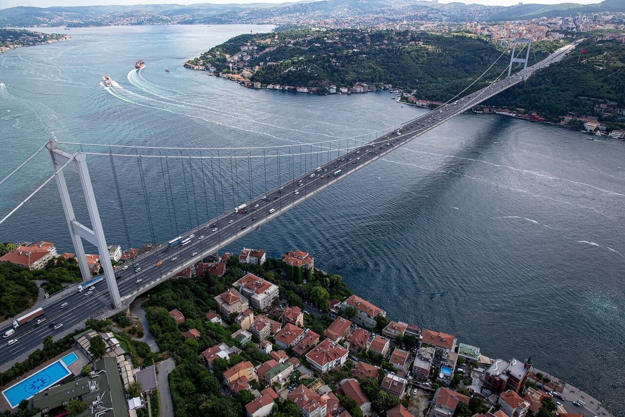 Cruzeiros do Bósforo
BOSPHORUS BRIDGE AND A RIVER CONNECTS EUROPE AND ASIA
Pontes de Bósforo
O Estreito do Bósforo, que divide Istambul e a Turquia Europeia, é um estreito natural e uma importante via navegável no mundo. Ele separa a Anatólia e Trácia na Turquia e faz parte da fronteira continental entre a Ásia e a Europa.
Com exceção da parte mais setentrional do Estreito do Bósforo, ambos os lados estão cheios de pessoas, com 17 milhões de pessoas vivendo na área metropolitana de Istambul.
O Estreito do Bósforo e o Estreito das Dardanelas, no outro extremo do Mar de Mármara, formam os Estreitos Turcos.
Partes do Estreito do Bósforo que tendem a ficar em lama sobre eles são periodicamente drenadas, e em alguns lugares ao longo de Istambul, a costa foi reforçada com concreto ou escombros.
Características geográficas do Bósforo
O Estreito do Bósforo liga o Mar Negro ao Mar de Mármara e, a partir daí, ao Estreito das Dardanelas, que liga o Mar Egeu e o Mediterrâneo. O Mediterrâneo Oriental, os Balcãs, o Oriente Médio e o Oceano Eurássico Ocidental estão todos ligados por esta massa terrestre. Assim, o Bósforo é uma importante via navegável internacional, especialmente para mercadorias provenientes da Rússia. Ele conecta o Mar Negro ao Mediterrâneo, o Oceano Atlântico e o Oceano Índico através de Gibraltar e do Canal de Suez.
Located a short distance from Kurucesme in the Bosporus is a single, tiny island. In 1880, Sultan Abdülhamid II presented the island to the Armenian architect Sarkis Balyan, and since then it has become known as Galatasaray Island (Galatasaray Adasi). The island, now home to the Galatasaray Sports Club after having been a walled garden and a water sports center, was once the site of his home. However, it became overbuilt with nightclubs in the 2010s, and many of them were demolished in 2017. In the summer of 2022, it reopened to the public.
A História do Bósforo
The Bosporus has been and continues to be a vital passageway for trade and defense because it connects the Black Sea and the Mediterranean. Russia and Ukraine, among others, use this waterway extensively. The Dardanelles Strait has been contested in several modern wars, including the Russo-Turkish War (1877–78) and the Allied Powers' attack on the Dardanelles in World War I's Battle of Gallipoli (1915). The significance of the Bosporus as a grain route to the rest of the world was brought into sharp focus in 2022 when Russia invaded Ukraine.
O Bósforo na mitologia
Na mitologia grega, o Bósforo é nomeado após o personagem Io, que foi transformado em uma vaca e condenado a vagar pela Terra até chegar ao Estreito do Bósforo, onde ela foi finalmente resgatada do dragão que a estava perseguindo.
As rochas de choque, ou Symplegades, eram enormes rochas flutuantes que se dizia que tinham guardado ambos os lados do Bósforo na mitologia grega e derrubado qualquer navio que tentasse passar pelo estreito.Jason, o herói dos Argonautas, foi capaz de passar com segurança entre as rochas.
As pontes do Bósforo
Three bridge types span the Bosphorus: two suspension bridges and a cable-stayed bridge. The 15th July Martyrs Bridge, originally named the Bosporus Bridge, was completed in 1973 and measures 1,074 meters (3,524 feet) in length. The second bridge, named Fatih Sultan Mehmet (Bosporus II) Bridge, was finished in 1988 and is located about 5 kilometers (3 miles) to the north of the first.
The Fatih Sultan Mehmet Bridge is part of the Trans-European Motorway, while the first Bosporus Bridge is part of the O1 Motorway. The third bridge is the 2,164-meter-long (7,100-foot-long) Yavuz Sultan Selim Bridge, which was finished in 2016. It is part of the "Northern Marmara Motorway," integrated into the already existing Black Sea Coastal Highway, and it allows through traffic to avoid city traffic near the northern end of the Bosporus, between the villages of Garipce on the European side and Poyrazköy on the Asian side.
The Bosphorus Bridge
One of three suspension bridges spanning the Bosphorus strait (Turkish: Bogazici) in Istanbul, Turkey, the Bosphorus Bridge (Turkish: Bogazici Köprüsü) is also known as the First Bridge (Turkish: Birinci Köprü) and the 15 July Martyrs Bridge (Turkish: 15 Temmuz Sehitler Köprüsü) (alongside the Fatih Sultan Mehmet Bridge and the Yavuz Sultan Selim; both Ortaköy (in Europe) and Beylerbeyi (in Asia) are connected by this bridge in Asia).
As torres de aço e as pendentes inclinadas criam uma ponte de suspensão que depende da gravidade. Os cabos de aço suportam o deck aerodinâmico. Tem um comprimento de 1,560 metros (5,118 pés) e uma largura de 33,40 metros (105 pés; 110 pés). A largura principal é de 1,074 metros (3,524 pés) de comprimento, e a torre mais alta é de 165 metros (541 pés) acima do solo. A 64 metros acima do nível do mar, a ponte tem muito espaço para passar (210 pés).
The Bosphorus Bridge, which opened to traffic in 1973, boasted the longest suspension bridge span anywhere in the world outside of the United States (only the Verrazano-Narrows Bridge, the Golden Gate Bridge, and the Mackinac Bridge had a longer span in 1973).
The Humber Bridge in 1981 surpassed the Bosphorus Bridge as Europe's longest suspension bridge, and the Fatih Sultan Mehmet Bridge (the Second Bosphorus Bridge) in 1988 surpassed it in Asia (which was surpassed by the Minami Bisan-Seto Bridge in 1989). The suspension bridge span of the Bosphorus Bridge is the 42nd longest in the world as of this writing.
Em 25 de julho de 2016, o primeiro-ministro Binali Yildirim anunciou que o gabinete da Turquia decidiu renomear oficialmente a ponte 15 Temmuz Sehitler Koprüsü (Ponte dos Mártires de 15 de julho) em homenagem aos que morreram lutando contra a tentativa de golpe militar em 15 de julho de 2016.
The Bosphorus Bridge is well-known because it links different parts of Europe and Turkey.
Ponte Fatih Sultan Mehmet
Localizado em Istambul, Turquia, através do Estreito do Bósforo é a Ponte Fatih Sultan Mehmet (também escrito Fatih Sultan Mehmed Köprüsü, F.S.M. Köprüsü, ou 2. Köprü), também conhecido como a Ponte Sultan Mehmed o Conquistador (Turco: Bogazici). Quando foi inaugurado em 1988, ele tinha a quinta maior ponte de suspensão do mundo.
The Ottoman sultan Mehmed the Conqueror, who in 1453 took control of Constantinople (modern-day Istanbul), named the bridge after himself. Highways 1 and 5 in Asia, as well as Otoyol 2 in Turkey, all converge here from Europe. In addition to the Bosphorus Bridge and the 1915 Canakkale Bridge, Turkey is home to three other bridges that span the continents of Europe and Asia: the Yavuz Sultan Selim Bridge, the 15 July Martyrs Bridge, and the Bosphorus Bridge.
Localização
Connecting Istanbul's European district of Hisarüstü to the Asian district of Kavacik is this bridge (Asian side). It uses steel pylons and vertical hangers to create a suspension bridge that is anchored to the ground by gravity. Two vertical steel cables support the aerodynamic deck. It has a deck width of 39 m and is 1,510 m in total length. The main span is 1,090 meters, and the towers rise 105 meters above the surrounding landscape. The bridge has a 64-meter vertical clearance above mean sea level.
Ponte Yavuz Sultan Selim
Located to the north of two existing suspension bridges in Istanbul, Turkey is the Yavuz Sultan Selim Bridge, also known as the Yavuz Sultan Selim Köprüsü. The original name for this bridge was the Third Bosphorus Bridge (with the 15 July Martyrs Bridge being the First Bosphorus Bridge and the Fatih Sultan Mehmet Bridge being the Second Bosphorus Bridge). Garipce in European Sariyer and Poyrazköy in Asian Beykoz is where the bridge connects, and both are close to the Black Sea entrance to the Bosphorus strait.
Em 29 de maio de 2013, foi realizada a cerimônia de colocação da pedra fundacional.Em 26 de agosto de 2016, a ponte foi aberta ao tráfego de veículos.
The bridge is 322 meters (1,056 feet) tall, making it one of the world's tallest. As far as bridges go, it comes in at number five on the list of the world's tallest. At 58.4 meters (192 feet), the bridge is also among the widest suspension bridges in the world.
Perguntas frequentes sobre as pontes do Bósforo
QO que são as pontes do Bósforo?
AAs Pontes do Bósforo são duas pontes que atravessam o Estreito do Bósforo em Istambul, Turquia.
QQuando foram construídas as pontes do Bósforo?
A: The first Bosphorus Bridge was completed in 1973, the second Bosphorus Bridge was completed in 1988, and the third Bosphorus Bridge was completed in 2017.
QQual é o propósito das pontes do Bósforo?
AAs pontes do Bósforo são uma ligação importante entre as partes europeias e asiáticas de Istambul.
Q: What is the name of the first Bosphorus Bridge?
A: The first Bosphorus Bridge is called the 15 July Martyrs Bridge.
Q: What is the name of the second Bosphorus Bridge?
A: The second Bosphorus Bridge is called the Fatih Sultan Mehmet Bridge.
Q: What is the name of the third Bosphorus Bridge?
A: The third Bosphorus Bridge is called the Yavuz Sultan Selim Bridge.
QQuanto tempo duram as pontes do Bósforo?
A: The 15 July Martyrs Bridge is 1,560 meters long, while the Fatih Sultan Mehmet Bridge is 1,408 meters long.
QOs carros podem andar nas pontes do Bósforo?
ASim, ambas as pontes têm estradas para carros, bem como caminhadas para pedestres.
QHá uma taxa para atravessar as pontes do Bósforo?
A: Sim, há uma taxa para atravessar as Pontes do Bósforo. A taxa varia dependendo do tipo de veículo.
QAs pontes do Bósforo estão abertas 24 horas por dia?
ASim, as pontes do Bósforo estão abertas 24 horas por dia.
QAs pontes do Bósforo podem ser vistas a partir de um passeio de barco pelo Estreito do Bósforo?
ASim, passeios de barco do Estreito do Bósforo normalmente passam sob as Pontes do Bósforo e oferecem vistas das pontes da água.
Você pode reservar um passeio pela cidade de Istambul com nossos guias de viagem licenciados.
Mapa do Bósforo